Otter Brook- Keene NH
Intro
 |
Figrue 1: (Wood
2016) #9 basket looking back at outcrops
of Rangley schist.
|
The
drive to Keene, New Hampshire from Boston is diverse and scenic. One starts the drive amongst brownstones and
triple deckers underlain by the late Precambrian puddingstone and shales of the
Avalon terrain, African in Origin. As you
travel northwest, away from the city along route 2 the scene turns more pastoral, open fields and
rolling deciduous forests that sit atop tortured stone, the remnants of ancient
mountain building events from the great collisions that built Pangea. The hills get larger and the bedrock more
prominent as you pass from the Nashoba Terrane, through the Merrimack belt and
into the central Maine Terrane. The
landscape becomes more forested and wild, interrupted every ten miles or so by
quaint New England towns. One passes
Mount Monadnock near the boarder of New Hampshire, standing tall, resistant to
the wind, rain and even the glaciers of a millennia ago. Finally after
following deep gorges cut deep by streams you enter Keene and Otter Brook State
Park. To travel from Boston to Keene region is to cross continents, to enter
the hinge that once was the edge of North America. A lot of what makes Otter
Brook unique, its rugged, sometimes chaotic topography, its piles of stones and
its ever sifting character ties back to its geology, it is a place of
transition, from continent to basin, from Africa to North America, from till to
bedrock, from exposed to buried, from primal nature to man-made, it is a place
of flux frozen in time.
 |
| Figure 2 (USGS 2016, modified by Wood 2016) Google Earth map of Major Geotectonic Terranes from Boston to Keene. Greens are outcrops of the Avalon Terrane; Orange is outcrops of Nashoba Terran; ,Periwinkle is outcrops of the Merrimack belt or Central Main Terrane; Dark Blue is outcrops of the Bronson Hills Volcanic Belt; Yellow is outcrops in the Hartford/Springfield Basin. |
Tectonic setting
Rising as a set of hills in western New Hampshire and
central Massachusetts is the Bronson Hills Volcanic Belt. It forms a strip of
older, igneous, volcanic and metamorphic rocks that were the core of a volcanic
chain that formed off the coast of North America in Ordivician time (around 480
MYA) when the Iapetus ocean started to close.
Sediments from this volcanic chain was deposited to the east in the open
ocean, forming vast piles of sediment that became the Rangley formation, which
the bedrock foundation of the Otter Brook area.
This depositional basin of the Rangley formation closed during the
Acadian orogeny (420 -370 MYA) as at least two subcontinents collided with
North America (Avalonia and Ganderia).
This event was long, complex and still being studied and
understood. The sediments caught between
these sub-continents including the Rangley formation were profoundly changed by
this event. It compressed them, realigned
its mineral grains, contorted and in some cases obliterated its original
sedimentary bending and it heated them to temperatures so high that they
partially melted. The rocks of the
Rangley formation were pushed them eastward against the hard unyielding core of
the Bronson Hills Belt which acted like a giant backstop, forcing them upward,
folding the sediments over themselves to make tight anticlines and synclines
and pushing the Rangley in the vicinity of Otter Brook, vertical, with younger
rocks to the east and older to the west.
 |
| Figure 3 (Thompson 1985, Modified by Wood 2016). Geologic Map of the Monadnock Quadrange, Otter Brook section. Notice That Otter Brook DGC is located in the Rangley Formation stretching across the boarder between the Lower and undifferentiated Rangley. |
At Otter Brook it is difficult to see the original nature of
the rocks, but glimpses are still there. The grittiness of the schists comes
from sandstone layers in the original sediments, and subtle differences in the
color and composition of the rock reflect differences in the composition of the
original sediments. The deformation due
to the Acadian orogeny on the other hand is ever-present, foliation is nearly vertical
and folds and other convolutions of the layering and foliation of the rocks are
seen in many outcrops. The Rangley Formation at Otter Brook represents the
ancient margin of the North American continent 420 million years ago. Now that margin has become a suture in the
continent as it has been ploughed back, smashed and baked into heart of the
mountains of New England
Roadcut
 |
Figure 4: (Wood
2016). North side of roadcut (My car for
scale). Notice
red ferriogeous schist at
far end of the oucrop, grey schist in middle
and migmatiteat close end of
outcrop. This is the bedrock that
underlies the large ridge which holes 1-3 and 7-9 play on.
|
One of the most unique opportunities that Otter Brook
presents to the geologist/disc golfer is not even on the course itself, but
next to it. Just west of the turnoff for
the park is a large roadcut that slices through a high ridge that much of the
disc golf course is built on. Being only
a few hundred feet away from some of the holes, looking at the roadcut is an
excellent way of seeing what is going on underneath the ground at Otter
Brook. The easiest way to divide the
rocks you see in the cut is by color, distinct areas of red, grey and white can
be seen. The reddish rock is most prevalent
on the east side of the cut. It is a
ferruginous schist, having begun as marine siltstone and shale this rock has
undergoing a high degree of metamorphism, changing its original mud into platy
minerals like mica and chlorite. It has a strong vertical foliation expressed
by orientation of the mica grains. The reddish hue is due to iron content in
the rock which “rusts” and turns red when exposed to air. The grey rock is most striking in the center
of the cut as it forms what looks like a shear grey wall, it again is a strongly
foliated schist, but with a lower iron content, hence a grey rather than
reddish appearance. It has a similar
origin to the ferruginous schist and in some places these two rocks cannot be
distinguished from each other. In places
this schist is interrupted by small pods of white rock, near these pods the
foliation is often disturbed and deformed.
The white rock is very different from the schists, it shows no clear
foliation but rather is made of interlocking crystals of feldspar, quartz and biotite
mica. This rock is migmatite and is formed when a
rock is heated to a point that some (but not all) of it melt. When the melted portion recrystallizes, it forms
migmatitie. Notice that the foliation of the grey schist is much more convoluted
near the migmatite. Keep these rock in
mind as you go down and play the course.
You will see them in bedrock outcrops and in loose talus. Otter Brook gives you a unique opportunity to
see a cross section of the rocks underneath the course.
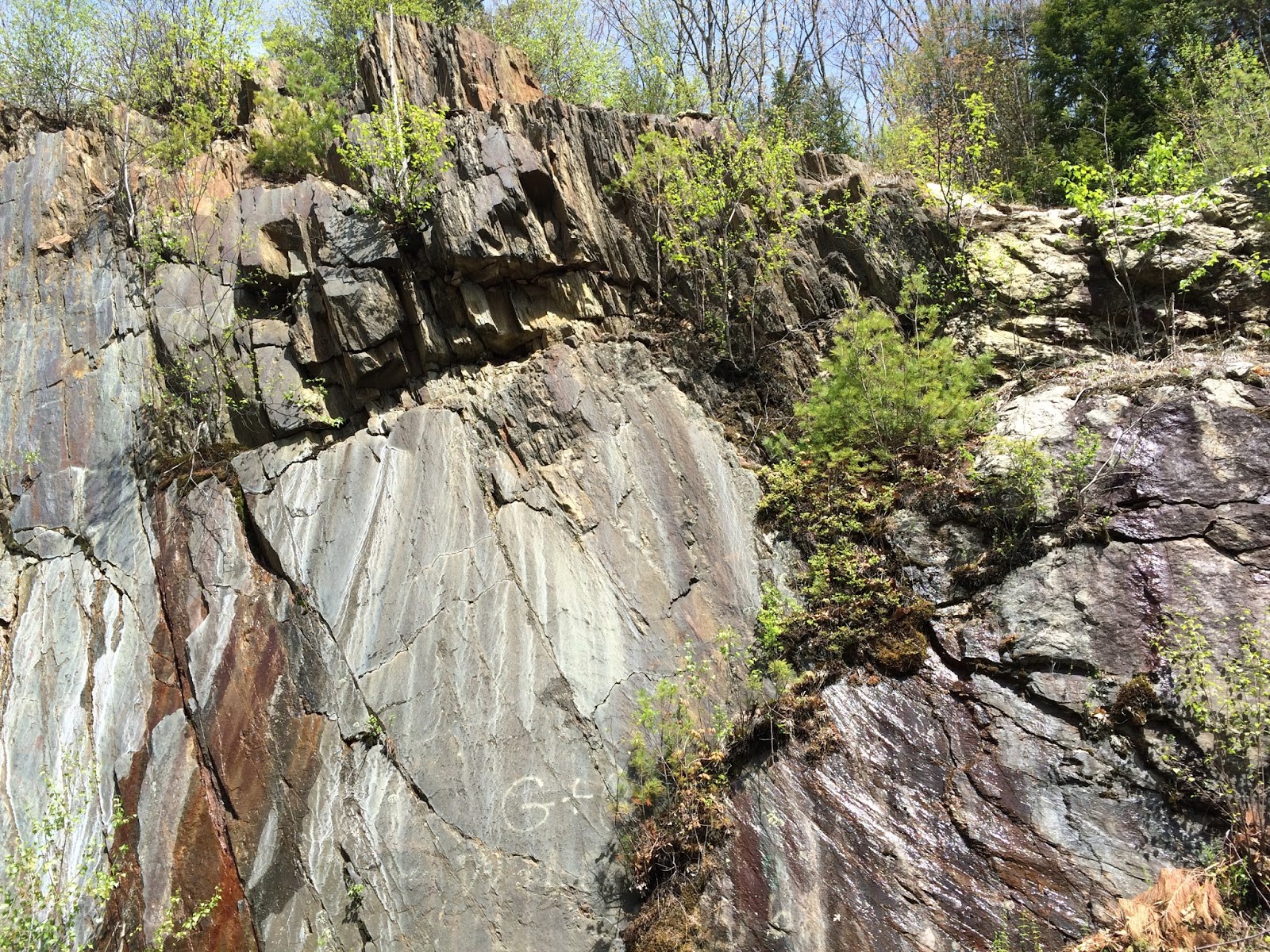 |
Figure 5: (Wood 2016).
At Roadcut, Grey schist, forming a nearly vertical wall.
|
 |
Figure 6: (Wood 2016) White migmatite surrounded by grey
schist. Notice the
more convoluted
foliation of the schist around the migmatite.
|
Glacial geology
 |
| Figure 7: (wood 2016) Hole #14, grounded covered by a thick glacial till with numerous erratics. |
Like most of New England, Pleistocene glaciation had a major
impact of the Otter Brook area. The
entire course is covered by a layer of glacial till that makes outcrops of
bedrock few and far between. The till
appears to be thinner and partially removed on the front nine of the course,
east of the ridge. The topography is often
chaotic, with steep slopes containing bedrock outcrops and flatter areas that
have between 5-10 feet of glacial till that is often held in place by tree
roots. Small streams cut this till in
places leaving earthy mounds. On the
back 9 of the course the till appears thicker and more constant. I could find
no bedrock outcrops on the back 9 and the terrain is more gentle and hummocky. The
cobbles and boulders in the till are different to the bedrock rock types
exposed in the roadcut and the front 9 of the course. Most prevalent is a biotite granite which has
a different texture and mineralogy from the migmatite in the bedrock,it has
smaller crystal grains and more numerous but much smaller mica flakes. It tends to occur as more rounded boulders
and might be the Fitzwilliam Granite that outcrops farther to the north and
west, carried here by glaciers. Gneisses
and schists of exotic origin are also found as erratics in the till, in some places
mixed in the Rangley red and grey schists making identifying the origin of many
of these rocks difficult.
 |
Figure 8: (Wood 2016).
Glacial erratic composded of fine grained biotite mica granite.
|
A geologic walkthrough of the course.
 |
| Figure 9: (Wood 2016) Otter Broojk |
 |
| Figure 10:(Wood 2016)
Glacial erratic containing large xenolith of metamorpohic rock in granite. Notice striped pattern in the metamorphic rock that contrasts to the massive texture of the granite. |
Hole #1 - You start
the course by climbing rapidly up the east side of the large ridge that bisects
the course. This area is still covered
with glacial till and most of the erratics here do not match the bedrock. A large erratic about halfway up the fairway
contains a xenolith, a piece of metamorphic rock that is surrounded by
granite. The xenolith is likely a piece
of the sedimentary or metamorphic rock that the granite intruded, it fell into
the molten magma but still retains some of its original foliation and mineralogy.
 |
Figure 11: (Wood
2016) Tee #3. Tee shot drops down
a steep hill of migmatite.
|
Holes 2-3 - Both
these holes play down the large ridge.
The hillsides are steep and contain a lot of boulders, some from till
but some also from the underlying bedrock.
White pieces of migmatite can been seen on the slopes of the ridge here,
and it is the hardness of the migmatite relative to the schist that likely
makes this ridge such a prominent feature.
 |
Figure 12: (Wood 2016)
Behind Hole #5 tee, grey schist
showing strong steeply dipping foliation.
|
Holes 4-6 - These
holes are relatively (compared to the rest of holes on the front 9) flat. The bedrock here is the grey schist and can
be seen in outcrop on hole six and in places to the left of 4. The till is heavily eroded here by streams
coming down from the north, making the terrain very bumpy. Rocks on the ground are a mixture of talus
from the ridge and boulders washed out of the till. Locals have made stacks of stone cairns on
these holes. You can see great examples of all the rocks here on these
holes. Yoda’s Swamp on hole 6 us a
marshy area caused by a small steam backing up behind a small ridge that separates
it from hole 4.
 |
Figure 13: (Wood 2016).
Looking towards hole #5 basket.
Cobble of quartzite in
foreground.
Numerous rocks on ground surface from partially removed glacial till
deposit. Basket sits on small hill of glacial till.
|
 |
Figure 14 (Wood 2016).
Yoda’s swamp, caused by backing up of small stream by
a small ridge
directly behind camera. Notice boulders
from glacial till
in foreground and road proximity to road in background.
|
 |
Figure 15: (Wood 2016)
Hole #7 tee.
|
Hole 7- You drive
from an elevated tee (likely underlain by more resistant schist) to a flat
fairway with a large number of stone cairns.
From this point you climb quickly back up the ridge. The ridge is made of migmatite in this
location, clear from the white rock fragments littering the slope. Take time to
look at pieces of the migmatite, in places it has feldspar and mica crystals
well over an inch long.
 |
Figure 16: (Wood
2016) Rock Cairns on fairway of #7.
|
 |
Figure 17: (Wood 2016)
Migmatite rock fragment. Note
large feldspar crystal just below disc.
|
 |
Figure 18: (2016) #7
fairway looking up to basket. Note
white rocks on
steep slope to basket, these are fragments of resistant
migmatite.
|
 |
Figure 19: (Wood
2016) Small fragment of migmatite with
large
crystal of biotite mica (black crystal directly above disc.
Notice
reddish coloration around mica grain due tro presence of iron.
|
Hole 8- Hole 8 takes
you to the top of the ridge. The first
part of the hole is underlain by more grey schist and then another area of
migmatite underlies the pin and outcrops behind and to the right of the hole,
making an impressive peak. Again look
for large crystals in the migmatite
 |
| Figure 20: (Wood 2016) Migmatite forming a bedrock ridge behind basket of hole #8. |
 |
Figure 21 (Wood 2016)
Outcrop of grey or rusty schist to left of #9.
Notice steeply dipping
folialtion in schist.
|
Hole 9- Now you go
down the other side of the ridge and into the lower Rangley. The white migmatite disappears and is
replaces by a steeply dipping and softer ferruginous schist. This schist is best seen to the left of the
fairway and on the path to the 10th tee. These are the last bedrock outcrops on the
course that I could find. As the ferruginous
schist is less resistant to erosion it does not pop out of the glacial till
like the migmatitie does.
 |
Figure 22: (Wood
2016) Hole #10, glacial erratics litter
the
stream that crosses the fairway.
|
Hole #10 By hole #10
you are now down the back side of the ridge an in an area covered by a thick
blanket of glacial till. As you cross
the stream notice the large number of boulders in its bed, these are erratics
in the till which the stream does not have the energy to carry away. These erratics tend to be granitic and were
likely from locations to the north of west.
 |
Figure 23 (Wood 2016).
Hole #13 basket. Large glacial
erratics
in till that dominate back 9 of course.
|
Holes 11-15- The rest
of the course sits on the glacial till.
It feels like a completely different course from the front 9. Considerable earth moving was done around
hole 12, as you can see old culverts and the pin sits on a small hill pushed up
by a backhoe or some other construction device.
Hole 13 contains lots of large erratics in front of the basket, while
hole 15 plays down the old road that likely led back to the earth moving area
at hole 12.
Hole 16- This odd
hole takes advantage of the chaotic terrain that can form on glacial till. The tee shot winds through innumerable trees
to the top of the large hummock. The
basket sits blind in an odd depression.
There are a couple of possible explanations for this depression. It could be man-made, a place where till was
excavated as the dam was built or it could be a depression formed by the
melting of a piece of ice in the till.
Just as rocks are deposited in till, large chunks of ice can be
deposited as well. When the ice melts
that land collapses above them forming a depression. When large enough they fill with water and
are called kettle ponds. This one is too
small and shallow to form a pond but might be formed through the same process.
Holes 17-18 - The
last holes of the course wind back down to Otter Brook, meandering through
numerous trees and more thick glacial till until reaching the mud and silt of
the Otter Brook floodplain.
Well I hope you enjoyed this look at Otter Brook. Next up the Quarries in Barre Vt. Rock piles, granite, giant pits of stone and
natural air conditioners.
References
Keene Disc Golf Club
http://www.keenediscgolf.com/
Robinson, Peter and Goldsmith, Richard. “Stratigraphy of the
Merrimack Belt, Central Massachusets.”
U.S. Geological Survey Professional Paper 1366 E-J. Washington D.C.:
1991. Electronic URL http://pubs.usgs.gov/pp/1366e-j/report.pdf
Skehan, James W. Roadside Geology of Massachusetts. Missoula:
Mountain Press Publishing Company, 2006. Print
Skehan, James W. Roadside Geology of Connecticut and
Rhode Island. Missoula: Mountain Press Publishing Company, 2008. Print
Thompson, Peter J. “Stratigraphy, Structure and Metamorphism
in the Monadnock Quadrangle, New Hampshire.”
Contribution #58 Department of Geology and Geography University of
Massachusetts, Amherst MA. 1985.
Van Diver, Bradford B.
Roadside Geology of Vermont and New Hamoshire. Missoula: Mountain
Press Publishing Company,1987. Print