Tuesday, July 26, 2016

Sorry I have not been able to add anything here for a while.  End of school, travel and personal life has kept me very busy.  I do have a little teaser though.  I am Akureyri Iceland right now and was able to get out an play a little 9 hole course here. Akureyri is only 60 km south of the artic circle, making this course one of the northern most courses in the world (a couple in Norway and one other in Iceland beat it). The course plays around an elementary school which is settled in between a couple of low basalt ridges (between 3-15 million years old).  Many holes on the course overlook the eyjafjodur fjord , which was carved by glaciers when they covered the entire island.


Glacial Polish on Basalt on top of ridge next to hole 1 Basket

Sunday, June 5, 2016

Otter Brook- Keene NH

Otter Brook- Keene NH

Intro

Figrue  1: (Wood 2016)  #9 basket looking back at outcrops
 of Rangley schist.
The drive to Keene, New Hampshire from Boston is diverse and scenic.  One starts the drive amongst brownstones and triple deckers underlain by the late Precambrian puddingstone and shales of the Avalon terrain, African in Origin.  As you travel northwest, away from the city along route 2  the scene turns more pastoral, open fields and rolling deciduous forests that sit atop  tortured stone, the remnants of ancient mountain building events from the great collisions that built Pangea.  The hills get larger and the bedrock more prominent as you pass from the Nashoba Terrane, through the Merrimack belt and into the central Maine Terrane.  The landscape becomes more forested and wild, interrupted every ten miles or so by quaint New England towns.  One passes Mount Monadnock near the boarder of New Hampshire, standing tall, resistant to the wind, rain and even the glaciers of a millennia ago. Finally after following deep gorges cut deep by streams you enter Keene and Otter Brook State Park. To travel from Boston to Keene region is to cross continents, to enter the hinge that once was the edge of North America. A lot of what makes Otter Brook unique, its rugged, sometimes chaotic topography, its piles of stones and its ever sifting character ties back to its geology, it is a place of transition, from continent to basin, from Africa to North America, from till to bedrock, from exposed to buried, from primal nature to man-made, it is a place of flux frozen in time.
Figure 2 (USGS 2016, modified by Wood 2016) Google
Earth map of Major Geotectonic Terranes from Boston to Keene.  Greens are outcrops
of the Avalon Terrane; Orange is outcrops of Nashoba Terran; ,Periwinkle is outcrops
 of the Merrimack belt or Central Main Terrane; Dark Blue is outcrops of  the Bronson
Hills Volcanic Belt; Yellow is outcrops in the Hartford/Springfield  Basin.

Tectonic setting

Rising as a set of hills in western New Hampshire and central Massachusetts is the Bronson Hills Volcanic Belt. It forms a strip of older, igneous, volcanic and metamorphic rocks that were the core of a volcanic chain that formed off the coast of North America in Ordivician time (around 480 MYA) when the Iapetus ocean started to close.  Sediments from this volcanic chain was deposited to the east in the open ocean, forming vast piles of sediment that became the Rangley formation, which the bedrock foundation of the Otter Brook area.  This depositional basin of the Rangley formation closed during the Acadian orogeny (420 -370 MYA) as at least two subcontinents collided with North America (Avalonia and Ganderia).  This event was long, complex and still being studied and understood.  The sediments caught between these sub-continents including the Rangley formation were profoundly changed by this event.  It compressed them, realigned its mineral grains, contorted and in some cases obliterated its original sedimentary bending and it heated them to temperatures so high that they partially melted.  The rocks of the Rangley formation were pushed them eastward against the hard unyielding core of the Bronson Hills Belt which acted like a giant backstop, forcing them upward, folding the sediments over themselves to make tight anticlines and synclines and pushing the Rangley in the vicinity of Otter Brook, vertical, with younger rocks to the east and older to the west.  
Figure 3 (Thompson 1985, Modified by Wood 2016).  Geologic
Map of the Monadnock Quadrange, Otter Brook section.  Notice
That Otter Brook DGC is located in the Rangley Formation
stretching across the boarder between the Lower and
undifferentiated Rangley.
At Otter Brook it is difficult to see the original nature of the rocks, but glimpses are still there. The grittiness of the schists comes from sandstone layers in the original sediments, and subtle differences in the color and composition of the rock reflect differences in the composition of the original sediments.   The deformation due to the Acadian orogeny on the other hand is ever-present, foliation is nearly vertical and folds and other convolutions of the layering and foliation of the rocks are seen in many outcrops. The Rangley Formation at Otter Brook represents the ancient margin of the North American continent 420  million years ago.  Now that margin has become a suture in the continent as it has been ploughed back, smashed and baked into heart of the mountains of New England         

Roadcut

Figure 4:  (Wood 2016).  North side of roadcut (My car for scale).  Notice
 red ferriogeous schist at far end of the oucrop, grey schist in middle
 and migmatiteat close end of outcrop.  This is the bedrock that 
underlies the large ridge which holes 1-3 and 7-9 play on.  
One of the most unique opportunities that Otter Brook presents to the geologist/disc golfer is not even on the course itself, but next to it.  Just west of the turnoff for the park is a large roadcut that slices through a high ridge that much of the disc golf course is built on.  Being only a few hundred feet away from some of the holes, looking at the roadcut is an excellent way of seeing what is going on underneath the ground at Otter Brook.  The easiest way to divide the rocks you see in the cut is by color, distinct areas of red, grey and white can be seen.  The reddish rock is most prevalent on the east side of the cut.  It is a ferruginous schist, having begun as marine siltstone and shale this rock has undergoing a high degree of metamorphism, changing its original mud into platy minerals like mica and chlorite. It has a strong vertical foliation expressed by orientation of the mica grains. The reddish hue is due to iron content in the rock which “rusts” and turns red when exposed to air.  The grey rock is most striking in the center of the cut as it forms what looks like a shear grey wall, it again is a strongly foliated schist, but with a lower iron content, hence a grey rather than reddish appearance.  It has a similar origin to the ferruginous schist and in some places these two rocks cannot be distinguished from each other.  In places this schist is interrupted by small pods of white rock, near these pods the foliation is often disturbed and deformed.  The white rock is very different from the schists, it shows no clear foliation but rather is made of interlocking crystals of feldspar, quartz and biotite mica.   This rock is migmatite and is formed when a rock is heated to a point that some (but not all) of it melt.   When the melted portion recrystallizes, it forms migmatitie. Notice that the foliation of the grey schist is much more convoluted near the migmatite.  Keep these rock in mind as you go down and play the course.  You will see them in bedrock outcrops and in loose talus.  Otter Brook gives you a unique opportunity to see a cross section of the rocks underneath the course.

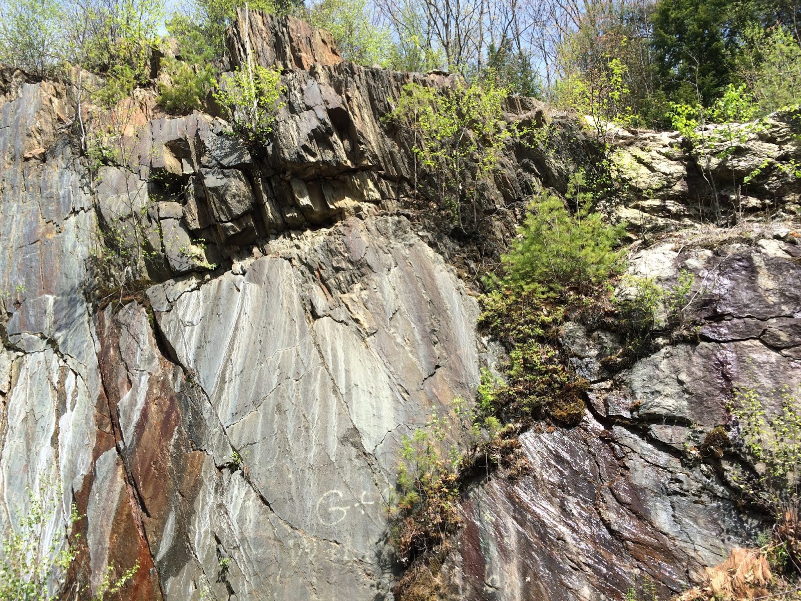
Figure 5: (Wood 2016).  At Roadcut, Grey schist, forming a nearly vertical wall.
Figure 6:  (Wood 2016)  White migmatite surrounded by grey schist.  Notice the
 more convoluted foliation of the schist around the migmatite.


Glacial geology

Figure 7: (wood 2016) Hole #14, grounded covered by a thick
glacial till with numerous erratics.
Like most of New England, Pleistocene glaciation had a major impact of the Otter Brook area.  The entire course is covered by a layer of glacial till that makes outcrops of bedrock few and far between.  The till appears to be thinner and partially removed on the front nine of the course, east of the ridge.  The topography is often chaotic, with steep slopes containing bedrock outcrops and flatter areas that have between 5-10 feet of glacial till that is often held in place by tree roots.  Small streams cut this till in places leaving earthy mounds.  On the back 9 of the course the till appears thicker and more constant. I could find no bedrock outcrops on the back 9 and the terrain is more gentle and hummocky. The cobbles and boulders in the till are different to the bedrock rock types exposed in the roadcut and the front 9 of the course.  Most prevalent is a biotite granite which has a different texture and mineralogy from the migmatite in the bedrock,it has smaller crystal grains and more numerous but much smaller mica flakes.  It tends to occur as more rounded boulders and might be the Fitzwilliam Granite that outcrops farther to the north and west, carried here by glaciers.  Gneisses and schists of exotic origin are also found as erratics in the till, in some places mixed in the Rangley red and grey schists making identifying the origin of many of these rocks difficult. 

Figure 8: (Wood 2016).  Glacial erratic composded of fine grained biotite mica granite.

A geologic walkthrough of the course.


Figure 9: (Wood 2016)  Otter Broojk
Unlike other dam courses in Massachusetts and Connecticut, Otter Brook plays entirely in heavy woods on a patch of forest between the open “dam” part of the park and the main highway.  Though hilly wooded courses are common in New England the combination of terrain, rockiness and thick forest makes the course memorable and unique. 


Figure 10:(Wood 2016)  Glacial erratic containing large xenolith of
metamorpohic rock in
  granite.  Notice striped pattern in the
 metamorphic rock that contrasts to the massive texture
 of the granite.

Hole #1 -  You start the course by climbing rapidly up the east side of the large ridge that bisects the course.  This area is still covered with glacial till and most of the erratics here do not match the bedrock.  A large erratic about halfway up the fairway contains a xenolith, a piece of metamorphic rock that is surrounded by granite.  The xenolith is likely a piece of the sedimentary or metamorphic rock that the granite intruded, it fell into the molten magma but still retains some of its original foliation and mineralogy.


Figure 11:  (Wood 2016)  Tee #3.  Tee shot drops down 
 a steep hill of migmatite.
Holes 2-3 -  Both these holes play down the large ridge.  The hillsides are steep and contain a lot of boulders, some from till but some also from the underlying bedrock.  White pieces of migmatite can been seen on the slopes of the ridge here, and it is the hardness of the migmatite relative to the schist that likely makes this ridge such a prominent feature.  


Figure 12: (Wood 2016)  Behind Hole #5 tee,  grey schist
 showing strong steeply dipping foliation.
Holes 4-6 -  These holes are relatively (compared to the rest of holes on the front 9) flat.  The bedrock here is the grey schist and can be seen in outcrop on hole six and in places to the left of 4.  The till is heavily eroded here by streams coming down from the north, making the terrain very bumpy.  Rocks on the ground are a mixture of talus from the ridge and boulders washed out of the till.  Locals have made stacks of stone cairns on these holes. You can see great examples of all the rocks here on these holes.  Yoda’s Swamp on hole 6 us a marshy area caused by a small steam backing up behind a small ridge that separates it from hole 4. 


Figure 13: (Wood 2016).  Looking towards hole #5 basket.  Cobble of quartzite in
 foreground.  Numerous rocks on ground surface from partially removed glacial till
 deposit.  Basket sits on small hill of  glacial till.
Figure 14 (Wood 2016).  Yoda’s swamp, caused by backing up of small stream by
 a small ridge directly behind camera.  Notice boulders from glacial till
 in foreground and road proximity to road in background.

Figure 15: (Wood 2016)  Hole #7 tee.
Hole 7-  You drive from an elevated tee (likely underlain by more resistant schist) to a flat fairway with a large number of stone cairns.  From this point you climb quickly back up the ridge.  The ridge is made of migmatite in this location, clear from the white rock fragments littering the slope. Take time to look at pieces of the migmatite, in places it has feldspar and mica crystals well over an inch long. 


Figure 16: (Wood 2016)  Rock Cairns on fairway of #7.  

Figure 17: (Wood 2016)  Migmatite rock fragment.  Note large feldspar crystal just below disc.

Figure 18: (2016)  #7 fairway looking up to basket.  Note white rocks on
 steep slope to basket, these are fragments of resistant migmatite.


Figure 19:  (Wood 2016)  Small fragment of migmatite with large
 crystal of biotite mica (black crystal directly above disc.
 Notice reddish coloration around mica grain due tro presence of iron.  
Hole 8-  Hole 8 takes you to the top of the ridge.  The first part of the hole is underlain by more grey schist and then another area of migmatite underlies the pin and outcrops behind and to the right of the hole, making an impressive peak.  Again look for large crystals in the migmatite


Figure 20: (Wood 2016)  Migmatite forming a bedrock ridge behind basket of hole #8.

Figure 21 (Wood 2016)  Outcrop of grey or rusty schist to left of #9.
 Notice steeply dipping folialtion in schist.
Hole 9-  Now you go down the other side of the ridge and into the lower Rangley.  The white migmatite disappears and is replaces by a steeply dipping and softer ferruginous schist.  This schist is best seen to the left of the fairway and on the path to the 10th tee.  These are the last bedrock outcrops on the course that I could find.  As the ferruginous schist is less resistant to erosion it does not pop out of the glacial till like the migmatitie does.


Figure 22: (Wood 2016)  Hole #10, glacial erratics litter the
 stream that crosses the fairway.
Hole #10  By hole #10 you are now down the back side of the ridge an in an area covered by a thick blanket of glacial till.   As you cross the stream notice the large number of boulders in its bed, these are erratics in the till which the stream does not have the energy to carry away.  These erratics tend to be granitic and were likely from locations to the north of west. 


Figure  23 (Wood 2016).  Hole #13 basket.  Large glacial erratics
 in till that dominate back 9 of course.
Holes 11-15-  The rest of the course sits on the glacial till.  It feels like a completely different course from the front 9.  Considerable earth moving was done around hole 12, as you can see old culverts and the pin sits on a small hill pushed up by a backhoe or some other construction device.  Hole 13 contains lots of large erratics in front of the basket, while hole 15 plays down the old road that likely led back to the earth moving area at hole 12. 


Hole 16-  This odd hole takes advantage of the chaotic terrain that can form on glacial till.  The tee shot winds through innumerable trees to the top of the large hummock.  The basket sits blind in an odd depression.  There are a couple of possible explanations for this depression.  It could be man-made, a place where till was excavated as the dam was built or it could be a depression formed by the melting of a piece of ice in the till.  Just as rocks are deposited in till, large chunks of ice can be deposited as well.  When the ice melts that land collapses above them forming a depression.  When large enough they fill with water and are called kettle ponds.  This one is too small and shallow to form a pond but might be formed through the same process.

Holes 17-18 -  The last holes of the course wind back down to Otter Brook, meandering through numerous trees and more thick glacial till until reaching the mud and silt of the Otter Brook floodplain.

Well I hope you enjoyed this look at Otter Brook.  Next up the Quarries in Barre Vt.  Rock piles, granite, giant pits of stone and natural air conditioners.

 References

Keene Disc Golf Club   http://www.keenediscgolf.com/
Robinson, Peter and Goldsmith, Richard. “Stratigraphy of the Merrimack Belt, Central Massachusets.”  U.S. Geological Survey Professional Paper 1366 E-J. Washington D.C.: 1991. Electronic URL  http://pubs.usgs.gov/pp/1366e-j/report.pdf
Skehan, James W. Roadside Geology of Massachusetts. Missoula: Mountain Press Publishing Company, 2006. Print
Skehan, James W. Roadside Geology of Connecticut and Rhode Island. Missoula: Mountain Press Publishing Company, 2008. Print
Thompson, Peter J. “Stratigraphy, Structure and Metamorphism in the Monadnock Quadrangle, New Hampshire.”  Contribution #58 Department of Geology and Geography University of Massachusetts, Amherst MA. 1985.   
Van Diver, Bradford B.  Roadside Geology of Vermont and New Hamoshire. Missoula: Mountain Press Publishing Company,1987. Print

Thursday, May 19, 2016

DeLaveaga- The Epicenter of Disc Golf

DeLaveaga- The Epicenter of Disc Golf

3-disc trip
On a recent trip to California I ended up with an unexpected extra day on my hands. So while my friends in the area went to work, I spent a Friday visiting one of the great old Disc Golf Courses, DeLaveaga in Santa Cruz.  I had no discs with me so I stopped at the local convenience store, picked up a Tern, River and Wizard, and went to throw some discs and study the geology of the epicenter of disc golf.
Figure 1:  (Wood 2016)  The Epicenter of Disc Golf

The Disc Golf Course at DeLaveaga was originally put in for the 1984 World Disc Golf Championships, cleaning up what had been a dumping ground and poison oak jungle behind the city of Santa Cruz.  The course eventually became permanent and its disc golf club became stewards for both the course and the wilderness that surrounds it.  Many of the original holes still exist while 11 more have been added to create the current 29 hole layout. The last hole, Top of the World has become one of the signature holes in all of disc golf a 500 foot hole with a nearly 100 foot elevation drop.  The vista from the tee with Santa Cruz and the Pacific Ocean as the backdrop is spectacular and memorable way to end a round.
Figure 2: (Wood 2016)  Hole 17 basket Purisima Formation on left.

Disc golf in an active plate margin

Figure 3: (Stouffer 2006, text from USGS 2006) Map of the
 modern San Andreas Fault in relation to the greater 
Plate-tectonic setting in western North America and the
 northeastern Pacific Ocean Basin.  The San Andreas Fault system
 connects between spreading centers in the East Pacific Rise
 (To the south) and the Juan de Fuca Ridge and Medicino fracture
 zone system (to the north).  The San Andreas fault system has
 gradually evolved since middle Tertiary time. The right-lateral
 offset that has occurred on the fault system since that time is
 about 282 miles; however, the fault system consists of many
 strands that have experienced different amounts of offset. 
Though both California and New England are filled with faults, folds and exotic terranes, the time when the events occurred is very different. In New England you are surrounded by layer upon layer of ancient history, the mountains and volcanoes are mere shadows of their active peak millions of years ago.  Along the California coast, the geology is fresh and active, happening before our eyes.  DeLaveaga is located about 8 miles west of the San Andreas Fault, which defines the boundary between the North American and Pacific tectonic plates.  The San Andreas Fault is a transform fault which means that the rocks on both sides of the fault are moving parallel and in opposite direction of each other, like two hands slipping past each other.  The west side of the fault is moving to the northwest at a rate of approximately 4 cm per year.  Though the San Andreas is the most well-known fault in California there are thousands of other faults.  Some are large, with kilometers of displacement and can cause major earthquakes, others are small with only a few feet of displacement and only minor earthquakes, some are no longer active and are only recognizable due to the rocks they displace or geomorphic features they cause.  In the San Francisco Bay Area the plate boundary movement is spread across several of these faults, including the San Andrea, Hayward, Calaveras and San Gregario faults.  Rather than a single line, the boundary between the North American Plate and the Pacific Plate is really zone of movement encompassing these parallel faults.  Delaveaga is within this zone, sitting between the San Andreas and the San Gregario Fault and a lot of its geology is a result of the deformation due to these faults movements.

1989

Figure 4: (H.G. Wilshire  US. Geological Survey 1989)-  Large 
cracks in ground formed during earthquake near house
 on summit road Santa Cruz Country CA.
A consequence of being on an active plate boundary is the occurrence of earthquakes.  If you rub your hands together there is friction, resistance to movement that can cause your hands to stick together. Like your hands, the rock units on both sides of a fault will often stick together as they move pass each other due to gradual movement over time.  Eventually the stress caused by this movements becomes large enough that the rocks move quickly accommodating all of the movement at once; this is an earthquake. Every year many Earthquakes are felt in the Santa Cruz area on many different faults, large and small.  Most of these earthquakes are small and cause little or no damage but every once in a while a large earthquake occurs. The last major earthquake in this region was in 1989.  This is the quake famous for disrupting the 1989 World Series.  I remember watching the TV just before the game got started, the screen going to static and then the announcers coming back on the air as the shaking wound down.  Instead of a baseball game I sat that evening transfixed by the coverage of collapsed bridges and buildings. It was my first experience with a Natural Disaster, live and in real time. The earthquake was a magnitude 6.9 earthquake, its epicenter in the mountains northeast of Santa Cruz.  The shaking lasted for 15 seconds and reached VIII on the Mercalli intensity scale throughout the Santa Cruz area, causing some buildings to collapses, cracking roads and causing many landslides in the mountain.   In the end 63 people were killed in the bay area and about 6 billion dollars worth of damage was caused.  The shaking would have been quite dramatic on the course, one would have wanted to move to one of the open spots on the course to wait it out as some limbs and maybe some old trees would have come tumbling to the ground a frightful experience but once away from trees, a disc golf course would be one of the safest places to be during an earthquake, much better that at a desk, on a bridge or at an indoor climbing wall.      

Purisima Formation

Figure 5 (Wood 2016)  View from tee of hole #2, Looking
 up-slope of hill at horizontal layers of Purisima Formation,
 more resistant layers form steeper slopes and softer layers
 gentler slopes.
The same forces that are responsible for the Earthquakes are also in some ways responsible for the bedrock the course sits on.  DeLaveaga Disc Golf course is underlain by sandstone and siltstone of the Purisima formation.  The Purisima was formed between 6-2 million years ago from sediment eroded from the Santa Cruz Mountains as they were uplifted due to deformation caused movement along the plate boundary.  The Purisima formation was deposited in relatively shallow water (usually less than 200m) near the source of the sandy sediment, probably in and environment not to unlike the modern Central California Coast.  The sediment was hardened into rock then both uplifted above sea level and broken up by local faults into several large blocks that stretch from Santa Cruz  to Point Reyes. Abundant fossils are found in the Purisima formation and ppint to its shallow Marine Origin, including various mollusks shells and whale bones.  Though the best preserved fossils are found on the coast near Santa Cruz and near Ano Nuevo State Park, casts and molds of mollusks can be seen in outcrops on holes #2, #3 and #27 as well as occasionally elsewhere on the course.  Casts and molds are created when sediment fills in the cavity or surrounds an organism.  After the original shell material dissolves away an imprint or shape of the shell is left.  The best place to look for these casts and fossils is on hole #2, where you climb through several different layers that are full of molds or casts, often reddish in color.  Though detail of the shells has been lost, the general shape and quantity of these creatures can still be seen.  The layers of the Purisima are nearly horizontal, dipping slightly southward towards the coast due to ongoing uplift of the Santa Cruz Mountains.  You can clearly see the horizontal nature of the formation on hole 2, 7 and 17 where slightly more erosion resistant layers make small 1-3 foot high ledges and on hole 19 where the basket is often on the top of an exposed resistant layer.
Figure 6 (Wood 2016)  Hole #2 fairway.  Molds and Casts of mollusks in Purisima Formation.
Figure  7: (Wood 2016)  Hole #2 Purisima Formation, mold or cast of mollusk
 with reddish coloration likely due to iron mineralization.
Figure  8:  (Wood 2016)  Hole #2 fairway looking towards basket.  More resistant layer
 of Purisima forming slight step in the hillslope.
Figure 9 (Wood 2016).  Hole #8 Basket, Purisima formation and large tree.

Fractures

With its location near many faults it is not surprising that the bedrock at DeLaveaga is heavily fractured.  Because of the similar appearance of much of the Purisima, it is difficult to tell if there has been much movement on most of these fractures.  When looking up the hill on 2 and 27 the layers appear to be continuous and show no vertical movement.  In some places fractures separate rocks of slightly different coloration, these could represent small fault offsets but also could just be coloration variations due to water percolation or other non-deformational causes.   Also some fractures have been mineralized, mostly with calcium carbonate.  The different directions, offset and mineralization on the fractures record a complex history of deformation due to stress put on the area from being in the middle of a plate boundary.
Figure 10  (Wood 2016)  Hole #15.  Purisima formation showing multiple parallel
 joints with no mineral fill.  These joints are likely related to the tectonic
 stresses due to the plate boundary. 
Figure 11:   (Wood 2016)   the Basket for #20 sits on the top of a more resistant
 Purisima Forrmation layer.  Numerous joints can be seen on the bedrock surface.

Figure 12: (Wood 2016)   Hole #21 basket.  Fracture in Purisima formation
 separating two layers of Purisima with differing colorations.   Possibly
 a small fault.  

Marine Terraces

Figure 13: (Wood 2016)  View from #27 tee “Top of the World”.  Note
 fairway below and hills in midground are part of the
 upper terrace.   Background is the lower terrace around Santa Cruz. 
If you drive down the Pacific Coast between Santa Cruz and Half Moon Bay, you will notice that the land rises from the ocean in a step like pattern with flat plateau separated by steep slopes.  The flat plateaus are wave cut terraces, formed by wave action eroded the bedrock when the sea level was at that elevation in the past.  The terraces along this part of the California Coast are not caused by sea level rising and falling, but by the land rising while sea level has remained “relatively” constant.  The Santa Cruz area has been uplifted in recent time because the San Andreas fault system, though mostly transform  in nature, has a compressional component due to its bending to the left (much like the San Bernardino Mountains near Los Angeles) causing the area to gradually rise in elevation.  This uplift has lifted old terraces to their current positions tens to hundreds of feet above sea level.  As you drive up to DeLaveaga Park you start on a lower terrace level in the residential neighborhoods, go up a steep wooded slope and reach a higher terrace around the ball golf course area (This is my amateur interpretation, I found no literature on the terraces exactly in this exact area, all the literature focused on terraces a few miles to the north or south).  This upper terrace extends back to the disc golf course area and is the flat surface that many of the holes of the course play on.  The Top of the World hill represents the back end of the terrace, rising above the flat platform like a cliff backing a beach.  Being older than the lower terrace the upper terrace is much more heavily eroded.  Gullies have cut deeply into the margins of the terrace and are in the process of cutting it down to the lower level.   It is this active erosion that is the cause of the extreme topography at the margins of the course, including steep drop offs to the right of holes 3-9 and to the left of holes 20-21.  Without this terrace, the course would look like any other mountain slope in the area, the terrace gives it the flat areas that make both disc and ball golf work well in the park.    

Figure 14: (Wood 2016)  Davenport CA, Wave cut terrace above current
coastline. This terrace is likely equivalant to the lower terrace
below DeLavega Park.
Figure 15:  (Tommy Slaton 2010)   Hole #27 from basket looking to tee.
  Lower part of fairway is part of wave cut terrace, break of hill most likely
 represents the inland extent of the terrace.


Hope you enjoyed this trip out to California as much as I did.  Up next is a trip to New Hampshire to see Yoda’s Swamp, rock cairns and road cuts at Otter Brook.

Course Webpage

contains info on history of course and hole by hole tour.

References

Brabb, E.E. (1997)  Geologic Map of Santa Cruz County California [geologic map]. https://pubs.usgs.gov/of/1997/of97-489/scruzmap.pdf

Powell, Charles L. United States Geological Survey Open File Report 98-594. (1998)  The Purisima Formationand Related Rocks (Upper Miocene – Pliocene), Greater San Francisco Bay Area, Central California.  https://pubs.usgs.gov/of/1998/of98-594/of98-594_2a.pdf

Powell, Charles L, Barron, John A., Sarna-Wojcicki, Andrei M., Clark, Joseph C., Perry, Frank A., 
Brabb, Earl B., and Fleck, Robert J.,  USGS Professional paper 1740. (2007)  Age, Stratigraphy and Correlations of the Late Neogene Purisima Formation, Central California Coast Ranges.  http://pubs.usgs.gov/pp/2007/1740/pp1740.pdf

United States Geological Survey. (1993).  Historic Earthquakes, Santa Cruz Mountains (Loma Prieta), California 1989.  http://earthquake.usgs.gov/earthquakes/states/events/1989_10_18.php

United States Geological Survey.  (2006) Geological History of the San Andreas Fault System. http://geomaps.wr.usgs.gov/archive/socal/geology/geologic_history/san_andreas_history.html


Weber, Gereld E and Allwardt, Alen  (2001).  The Geology From Santa Cruz to Point Ano Nuevo-  The San Gergario Fault Zone and Pleistocene Marine Terraces. https://pubs.usgs.gov/bul/b2188/b2188ch1.pdf

Sunday, May 1, 2016

Borderland Disc Golf Course

Borderland Disc Golf Course

Located around the Ames Estate at Borderland State Park, the disc golf course of Borderland has become a mainstay of disc golf in the eastern Massachusetts area.  It sits close to I 95 and is an easy drive from Boston and Providence.  One of the themes of Borderland is its variety, as it moves in an out of open fields and wooded lots, wrapping around a mansion built in the early 1900’s.  Two tees and two pin positions (white and blue) create four related but distinct layouts with distances that range from an intermediate par 3 course, to an 8500 ft. par 68 layout.  Borderland is one of the destination courses in Massachusetts and is a must to play if you are in the Boston or Providence areas.
Figure 1:  Hole 17 Blue Tee-  Ames Mansion in the Background.


The Avalon Terrane

The bedrock that underlies Borderland State Park is part of the Avalon Terrane.   If you form a line from Pye Brook in Topsfield to Simmonds Park in Burlington to Webster Fish and Game Club, anything southeast of this line is part of the Avalon Terrane, while to the west is the Nashoba terrane and the Merrimack Belt.  Similar rocks can be found in the Maritime Provinces of Canada, England and Scandinavia.  The Avalon Terrane is an exotic terrane, a region of bedrock that originally formed in a distant location that was then moved though plate tectonic processes to a new location making it “exotic” to the surrounding rocks.  The Avalon Terrane likely formed in Late Proterozoic time (around 700-600 MYA) just off or on the coast of Africa as a volcanic arc.  Rifting split this arc from Africa as a new ocean (The Rheic Ocean) opened in the Early Paleozoic time. By the Mid-Paleozoic the Avalon Terrane collided with the North American Continent causing what we call the Acadian Orogeny.  This event welded the Avalone terrain to what is now the east coast of North America.  In the Late Paleozoic the African continent itself collided with North America, causing the Alleghanian Orogeny.  Though not clearly seen at Borderland due to the massive nature of the bedrock, folding, and metamorphism due to the Alleghanian event affected the area.  This can be seen to the south in the Narragansett coal basin, where carbon rich sediments were turned to coal and the coal layers were compressed and folded.  During the Jurassic the opening of the Atlantic Ocean cut across the Avalone Terrane, some of it staying as part of the North American coast, while the rest became part of Northern Europe.
Figure 2: (From U.S. Geological Survey Modified by Wood 2016).  Map showing the terranes of Eastern Massachusetts.  Green areas represents the Avalon Terrane, Orange the Nashoba Terrane and Blue the Merrimack Belt/Terrane.   The lime green area just below borderlands is the Narragansett coal basin.   


The Dedham Granite

Figure 3:  (Wood 2016)   #3 Blue Basket perched
 on bedrock  outcrop of Dedham Granite.
The main rock type underlying Borderland is the Dedham Granite, a light pink to grey slightly porphyritic (large visible crystals) granite.  The Dedham granite has been dated between 630-595 MYA with the older range more prevalent in the Borderland area. The Dedham granite is part of what geologists call a batholith, which is a large emplacement of igneous rock.  The Dedham Granite is the intrusive core of the volcanic chain that formed the “backbone” of the Avalon Terrane when it was a volcanic arc off the coast of Africa.  In many ways it is a much older equivalent to the granites of the Sierra Nevada in California or the rocks that underlie the cascade volcanoes in the pacific northwest.  The rocks at Borderland are essentially the roots to an old volcanic chain.

Despite the complex tectonic history of the area the Dedham Granite shows very little deformation, surprising since it has moved around so much.  It still appears to retain its original crystalline structure though there are many faults and fractures in it. This is common with batholiths as they form a large massive block that is difficult to compress, fold and deform.  The Dedham granite only shows up as a bedrock outcrop on the rock ridge that forms the tees to holes 2 and 4 and the baskets to hole 3.  It  can also be seen as glacial erratics on other parts of the course and on as bedrock outcrops on hiking trails such as the ridge trail.  The #3 Blue basket is placed on top of the most dramatic outcrop of the granite on the course, where its crystalline structure and mineralogical make up can be easily seen. 

Figure 4:  (Wood 2016) From near #3 Blue basket looking straight down.  Close up of Dedham Granite showing its crystalline texture. Several small joints are present striking across the picture.  The Dedham granite is usually dull grey at Borderlands though some glacial erratics will have a more pink or orange hue.

Glacial History

The state of Massachusetts was covered by the continental ice sheet several times during the Pleistocene ice ages, and evidence of the most recent event, the Wisconsian, is plentiful at Borderlands.  Most of the disc golf course at Borderland is underlain by a significant layer of glacial till. Glacial till is an unsorted mixture of clay, silt, sand and boulders that was directly deposited by a glacier or ice sheet. The till at Borderlands was likely deposited as the Wisconsian ice sheet was melting and retreating back to the north.  As it melted the ice dropped all the material it was carrying forming the seemingly random mix material that is glacial till. The till layer is likely 15 or so feet thick and forms a mantle of material over the pre-existing bedrock topography, keeping its general shape.  The material in till can be transported by glaciers over great distances, sometimes on the scale of hundreds of miles.  We call the larger boulders in a till that have been transported large distances glacial erratics.  Glacial erratics are most easy to spot when they are made of a rock type not present in a local bedrock, so if you see a non-granite rock at Borderland, you are probably looking at a glacial erratic (or a chunk of asphalt or road rock).  The most impressive erratic at Borderlands is balancing rock, a large glacial erratic of Dedham granite that is on a trail between the 2 and 4 baskets.  It is impressive to think of the size of the glacier necessary to carry something so big.

Figure 5: (Wood 2016) glacial till cover on hole #1.
Figure 6:  (Wood 2016)  Balancing rock (Near Hole 4 Blue basket), A large Glacial erratic of Dedham Granite.  Note the large fracture running right down the middle that nearly splits the boulder in two. 


Rock Walls

There is an interesting interplay between glacial geology and human action that has a big impact of the feel of the course at Borderland.  The course winds its way through various segmented plots of land that surrounded the estate.  Most of these plots were originally used for agriculture in the 1800’s but over time these farms failed or people moved on.  The pebbles and boulders of glacial till caused big problems for New England farmers so they would be cleared from a field before plowing.  The farmers then used these boulders to build the stone walls that mark the field boundaries. The State Park has preserved the stone walls and they have become an integral part of the course, marking out of bounds and giving borderlands its unique feel.  Some boulders are too big to move though and these have to be left in the field and still remain to this day.  Holes 1,3,4 look to be on a plot of land that has not had its boulders cleared as the bedrock was close to or at the surface and contain plenty of rocky till.  Holes 2, 7, 11, 12, 17 and 18 re in areas that have been kept open, with only a few large boulders that farmers could not move.  Holes 8-10,13-16 play through a series of wooded lots that are fairly clear of small boulders.  These are farm fields that were cleared in the 1800’s but eventually went into disuse and forest has started to grow back.  Hole 5 is curious as it has a ton of boulders and is marshy.  My guess is that this was a swampy that was not conductive to agriculture, the area was never cleared, and extra boulders might have been put here to try to raise the ground level.  It is fascinating here that every time you cross a rock wall the plants and ground terrain change slightly, giving each hole a slightly different character.    
Figure 7  (Wood 2016).  Near 12 Blue tee, this is most likely a large glacial erratic of Dedham granite.  Boulders like this were way too large for farmers to move so they were left in the fields.
Figure 8:  (Wood 2016)  Hole #1 White basket.  The chaotic jumble of boulders and dirt here is typical of glacial till.  Unlike other places on the course the till on hole 1 appears relatively undisturbed by human actions like farming and wall building (though the forest does look like it was cut in the past). 
Figure 9:   (Wood 2016)  From left side of 11 fairway  10 Blue Basket in foreground, 11 baskets in distance.  Terrain typical of the cleared open lots.  Notice the two larger glacial erratics in front of the far basket. 
Figure 10:  (Wood 2016)  Hole 14 from white tee.  Typical topography of wooded terrain on back 9 of course.  Rock walls are present both Parallel to the fairway and cutting across it 150 ft. from tee.  The rock walls consist of boulders taken from the adjacent fields.  Larger boulders are still present in the field lots, such as the one on the right side of image.  Compare this to the rocky terrain on holes 1 or 5 where the boulders were not cleared. 
Figure  11:  (Wood 2016)  Hole 13 Blue basket.  Note rock wall and wooded field relatively clear of boulders.
Figure 12: (Wood 2016)  Hole #5 White tee.  This area is slightly lower and marshier than most of the rest of the course. Notice the abundance of boulders, in contrast to the cleared fields on the next several holes.  


I hope you enjoyed this look at the geology of Borderlands. Next will be something out of left field and left coast De Laveaga from Santa Cruz CA. 

Links and References

Borderland Disc Golf Homepage  -  http://www.borderlanddiscgolf.com/

Borderland Disc Golf Facebook Page - https://www.facebook.com/borderlanddg

Chute, Newton E, Geology of the Norwood Quadrange Norfolk and Suffolk Counties Massachusetts. Geology of Selected quadrangles in Massachusetts, Geoloigical Survey Bulletin 1163-B. 1966.  url http://pubs.usgs.gov/bul/1163b/report.pdf

Executive Office of Energy and Environmental Affairs, “Borderland park History and Culture”  Mass.gov website, retrieved 2016.  url  http://www.mass.gov/eea/agencies/dcr/massparks/region-south/borderland-park-history-and-culture.html

Goldsmith, Richard, “Stratigraphy of the Milford-Dedham Zone, Eastern Massachusetts: An Avalonian Terrane.”  U.S. Geological Survey Professional Paper 1366 E-J. Washington D.C.: 1991. Electronic URL  http://pubs.usgs.gov/pp/1366e-j/report.pdf

Pollock, Jeffrey C, Hibbard, James P, and Sylvester Paul J.  “Early Ordovician Rifting of Avolonia and Birth of the Rheic Ocean: U-Pb Detrital zircon constraints from Newfoundland.”  Journal of the Geological Society. May 2009.

Skehan, James W. Roadside Geology of Massachusetts. Missoula: Mountain Press Publishing Company, 2006. Print

Skehan, James W. Roadside Geology of Connecticut and Rhode Island. Missoula: Mountain Press Publishing Company, 2008. Print

Sorota, Kristin Joy.  Age and Origin of Merrimack Terrane, Southeastern New England: A Detrital Zircon U-Pb Geochronology Study.  M.S. Thesis. Boston College. 2013. Online.  Persistent link: http://hdl.handle.net/2345/3043

Wones, David R, and Goldsmith, Richard. “Intrusive Igneous Rocks of Eastern Massachusetts.” U.S. Geological Survey Professional Paper 1366 E-J. Washington D.C.: 1991. Electronic URL  http://pubs.usgs.gov/pp/1366e-j/report.pdf


Zen, E-an, Gildsmith, Richard, Ratcliffe, N.M., Robinson, Peter, Stanley R.S., Hatch, N.L., Shride, A.F.,Weed, E.G.A., and Wones, D.R.  Bedrock Geologic Map Of Massachusetts[map]. 1:250,000. U.S. Geological Survey. 1983